Attractions
The Hashemite Kingdom of Jordan, which once captivated ancient travellers, continues to enthral a whole new generation as a modern, vibrant nation.
From the haunting, primeval starkness of Wadi Rum, to the teeming centre of urban Amman, from the majestic ruins of bygone civilizations to the timeless splendour of the Dead Sea, Jordan is unveiled as a unique destination offering breathtaking and mysterious sights, high standard accommodations, exquisite cuisine and countless activities that can provide visitors with inspiration, motivation, and rejuvenation.
Marveling at herds of gazelles and oryx and migrating birds, camping amidst the grandeur of Wadi Rum or Dana Reserve, trekking the ancient caravan trails from the highlands of Moab and Edom, hiking the wooded hills of biblical Gilead, or experiencing the unique, cleansing mud baths of the Dead Sea are just a few examples of the treasures awaiting visitors to this unique kingdom.
The new stream of luxury hotels emerging in Amman, Petra, Aqaba and the Dead Sea is just adding quality to a refined product that is distinct, accessible and friendly; a product that is home to a new display of modern meeting facilities and unique venues for incentive travel as well.
Whether it is a conference for 5000 people, a lavish dinner in the peerless desert of Wadi Rum, a barbecue at the shores of the Dead Sea , or a reception atop a medieval castle overlooking the Jordan Valley, the amicable and competent people of Jordan will ensure a memorable, once in a lifetime experience.
GETTING AROUND
Amman and the surrounding cities are relatively small, and most places of interest – hotels and restaurants – are well-known. Street addresses are rarely used – mail is delivered only to post office boxes located at neighbourhood post office centres, while only the larger street names are commonly known. When giving directions, therefore, people will usually tell you the area or a nearby landmark (a large hotel, ministry building or supermarket, for example) and specific instructions from there. This works more efficiently than it sounds.
Amman itself is built on seven hills, or “jabals,” each of which more or less defines a neighbourhood. Many jabals once had a traffic circle (roundabout) at their peak and, although most of the circles have now been replaced by traffic lights, the junctions are still known as 1st Circle, 2nd Circle… 8th Circle. Other Amman neighbourhoods were once separate villages, now swallowed up by the expanding city.
AMMAN
A sprawling city spread over 19 hills, or “jebels,” Amman is the modern – as well as the ancient – capital of the Hashemite Kingdom of Jordan. Known as Rabbath-Ammon during the Iron Age and later as Philadelphia, the ancient city that was once part of the Decapolis league, now boasts a population of around 2.3 million people. Amman, often referred to as the white city due to its low size canvas of stone houses, offers a variety of historical sites. There are a number of renovations and excavations taking place that have revealed remains from the Neolithic period, as well as from the Hellenestic and late Roman to Arab Islamic Ages. The site which is known as the Citadel includes many structures such as the Temple of Hercules, the Umayyad Palace and the Byzantine Church. At the foot of the Citadel lies the 6,000 seat Roman Theatre, which is a deep-sided bowl carved into the hill and is still being used for cultural events. Another newly restored theatre is the 500-seat Odeon that is used for concerts. The three museums found in the area offer a glimpse of history and culture; they are the Jordan Archaeological Museum, The Folklore Museum and the Museum of Popular Traditions.
Amman’s history spans nine millennia dating back to the Stone Age. It boasts one of the largest Neolithic settlements (c.6500 BC) ever discovered in the Middle East. The Citadel hill contains early Bronze Age tombs (3300-1200 BC).
By the beginning of the Iron Age Amman had become the capital of the Ammonites, referred to in the Bible, and was called Rabbath-Ammon. It was here that King David of Israel killed Uriah the Hittite. Fortress towers ringed the city at that time – the best preserved of these can still be seen today – but they were little protection against King David’s attack. His forces toppled the Ammonites and, apart from a brief revival in the 9th and 8th centuries BC, the area was ruled in succession by the Assyrians, Babylonians and Persians for several hundred years. By the 4th century BC the city had been renamed “Philadelphia” after its Ptolemaic ruler, Philadelphus.
Seleucid and Nabataean rule followed until 63 BC, when it was absorbed into the Roman Empire and the Roman general, Pompey, annexed Syria and made Philadelphia part of the Decapolis League – an alliance of ten free city states with overall allegiance to Rome. The Romans rebuilt the city with colonnaded streets, baths, a theatre and impressive public buildings. Philadelphia found itself at the centre of the new Roman province of Arabia and of lucrative trade routes running between the Mediterranean and an interior that stretched to India and China as well as routes north and south. The city flourished.
During the Byzantine period, when Christianity became the official religion of the Eastern Roman Empire, the city was the seat of a Christian Bishop and two churches were constructed. By the early 7th century, Islam was already spreading northwards from the Arabian Peninsula and, by 635 AD, had embraced the land as part of its domain. The city returned to its original Semitic name of Ammon or, as it is known today, Amman.
With various shifts in political power over the following centuries, Amman’s fortunes declined. During the Crusades and under the Mameluks of Egypt, Amman’s importance was overtaken by the rise of Karak in the south. By 1321 AD, it was reported that Amman was “a very ancient town and was ruined before the days of Islam” there are great ruins here and the river al-Zarqa flows through them.”
Under the Ottoman Empire, Amman remained a small backwater with As-Salt being the main town of the area. By 1806, the city was reported to be uninhabited except for the Bedouins.
The departure of the Ottomans from the region coincided with the exodus of a large numbers of Circassian and other persecuted Muslims from the Caucasus. They found refuge in the area and established a settlement on the east bank of the Jordan River. Although they were mostly farmers, amongst these early settlers there were also gold and silversmiths and other craftsmen, and it wasn’t long before they built rough roads linking their settlement to Amman. Commerce, once again, began to flourish.
Adventure
Amman is a good base for action-packed activities in the surrounding area. The Jordan Valley is just a short drive away and easily accessible for day excursions for walking, hiking, riding, sports and much more.
Within Amman there is plenty of fun to be found including water parks with lots of thrilling rides to keep the children entertained. There is a wide range of health clubs and fitness centres, as well as facilities for paintballing and other action-packed sports.
RELIGION & FAITH
Amman is one of the oldest continuously inhabited cities in the world and there are many Biblical references to the city, which was then known as Rabbath-Ammon. Later renamed Philadelphia (after the Ptolemaic ruler Philadelphus), the city also became part of the Decapolis League, an alliance of ten Roman-ruled cities including Jerash, Gadara (present-day Umm Qays), Pella, Arbila (Irbid) and others. During the Byzantine period, Philadelphia was the seat of a Christian bishop, and a number of impressive churches were built here.
The Citadel, which towers above the city from Jabal Al-Qala’a, is the site of ancient Rabbath-Ammon, and excavations here have uncovered Roman, Byzantine and early Islamic remains. The most impressive of which, known simply as Al-Qasr (“the Palace”), dates back to the Islamic Umayyad period. Nearby are the ruins of Umayyad palace grounds.
Close by are the remains of a small Byzantine basilica while roughly 100m south of the church is what is thought to have been a temple of Hercules – also known as the Great Temple of Amman – which was built during the reign of Emperor Marcus Aurelius.
The King Hussein Bin Talal Mosque, also known as Al-Husseini Mosque, is an Ottoman-style mosque rebuilt in 1924 on the site of an ancient mosque. Amman’s famous gold souq is just a short distance away. The Mosque was inaugurated in 2006 and became the country’s national mosque. It is also the largest mosque in the country and was built to reflect the Umayyad architecture prevalent in many historic sites around Jordan.
MUSEUMS
Jordan Archaeological Museum was built in 1951 on the Citadel Hill in Amman. It houses artefacts from all the archaeological sites in the country. The collection is arranged in chronological order and represents ancient items of daily life such as pottery, glass, flint and metal tools, as well as monumental materials such as inscriptions and statuaries. The museum also houses several jewellery inscription statuary and coin collections.
The archaeological periods represented in the museum are:
- The Paleolithic (1000,000 – 10,000 years ago).
- The Pre-pottery Neolithic (8300-5500 BC).
- The Pottery Neolithic (5500-4300 BC).
- The Chalcolithic (4300-3300 BC).
- The Early Bronze Age (3300-1900 BC).
- The Middle Bronze Age (1900-1550 BC).
- The Late Bronze Age (1550-1200 BC).
- The Iron Age (1200-550 BC).
- The Persian Period/Iron III (550-350 BC).
- The Hellenistic Period (332-63 BC).
- The Nabataean Period (312 BC-AD 106).
- The Roman Period (63 BC – AD 324).
- The Byzantine Period (AD 324 – 636).
- The Islamic Era (AD 636 – the present).
a- The Umayyad Period (AD 661 – 750).
b- The Abbasid Period (AD 661 –750).
c- The Ayyubid/Mamluk Period (AD 1173 –1516).
Among the most important exhibits in the museum are the plaster statues from ‘Ain Ghazal, dating back to around 6000 BC, and the Dead Sea bronze scroll written in Aramaic characters.
The Jordan Folklore Museum is located within the western section of the Roman Theatre in Amman. This museum was founded by the Department of Antiquities and officially opened in 1975. The museum houses items representing the following Jordanian cultures:
- The culture of the desert (Bedu).
- The culture of the villages (Reef).
- The culture of the towns and cities (Madineh).
The collection of the museum represents items of daily life from the nineteenth and early twentieth centuries, such as:
- Costumes of the various areas in Jordan.
- Utensils used for food preparation, making bread, coffee, and tea.
The Jordanian Museum of Popular Traditions was established in 1971. The museum is located within the eastern section of the Roman Theatre in Amman. Its aims are to collect Jordanian and Palestinian folk heritage from all over Jordan, to protect and conserve this heritage and to present it for future generations. The museum is also concerned with introducing our popular heritage to the world.The museum has five exhibition halls. The first hall is dedicated to the traditional costumes of the East Bank. In the second hall, the traditional jewellery and cosmetic items of the various regions in the East and West Banks are on display.
The third hall contains a collection of Palestinian costumes and heard-dresses. In the fourth hall there is a collection of pottery and wooden cooking pots and food preparation vessels, as well as a collection of silver jewellery and bridal dresses from the West Bank. The fifth hall, which is in a vault of the Roman Theatre, houses a collection of mosaics from Byzantine churches in Jerash and Madaba.
The Archaeological Museum / University of Jordan
A small archaeological museum was initially established at the University of Jordan in 1962. The museum was later expanded and transferred to its present location; the new building was officially opened in1986.
The museum has exhibition halls, research workshops, photography and draughting rooms, and a conservation laboratory. The objectives of the museum are as follows:
- To intensify knowledge of Jordan’s cultural heritage throughout the ages.
- To organize traveling and temporary exhibits in Jordan and abroad.
- To continually develop the museum in accordance with the scientific status of the university.
- To establish cooperation with national and international scientific departments and institutions.
- Documentation of the museum processes, starting with obtaining the cultural material up to labeling, conserving, displaying and properly storing the objects.
- Preparation of accurate and comprehensive lists of the objects on display and in storage.
- Teaching of the applied courses in archaeology.
- The museum is an academic centre striving to develop and research archaeology by offering facilities to the teaching staff at the Department of Archaeology at the University
The Anthropological Museum / University of Jordan
The idea of establishing an anthropological museum at the University of Jordan started in 1977, to serve as an application grounds for theoretical courses taught at the Department of Sociology concerning social life in Jordanian society.
Originally, students of anthropology classes gathered elements of Jordanian heritage from their own homes and donated them to the university, and an exhibition of Jordanian folk heritage took place in 1981. Consequently the exhibition developed into the present museum through the concern of the president of the university.
The museum houses collections of modern Jordanian heritage, tools made by Jordanian people from their natural environment to meet their needs and demand. The collections of the museum are displayed according to their material and functions. They include agricultural tools, costumes, cosmetic items, and furniture, drinking and eating vessels, tents, and equipment for animals.
The objective of the establishment of the museum is to preserve modern Jordanian heritage as a testimony to the accomplishments of Jordanian society and its interaction with the environment. The museum also aims at offering means to study Jordanian society during a specific period of its history through the material cultural objects, especially those concerned with eating, drinking, costume and agriculture.
The Royal Society for Fine Arts established the Jordan National Gallery for Fine Arts at Jabal Al Weibdeh in Amman. A special wing for temporary exhibits was opened in 1984. The main aims of the Gallery are:
- The patronage of contemporary art in Jordan, the Arab countries, and the developing world.
- Exchange of exhibitions between the gallery and other museums and cultural organizations outside Jordan.
- Organizing and participating in seminars, conferences, and symposia pertaining to art and culture within and outside Jordan.
- Since its establishment, the Gallery has greatly expanded. Its collection, which started with around 50 works of art, amounts now to almost 2000, consisting of works by 520 artists from 43 Arab and Islamic countries, ranging from Brunei in the Pacific to Morocco on the Atlantic, and from Turkey and Iran on the Caspian Sea to Pakistan on the Indian Ocean. The Society has organized more than fifty exhibitions drawn from major sources in Europe and America, such as the Center Pompidou in Paris, the Victoria and Albert Museum in London, the Geneva Museum of History and Art and the Harvard Semitic Museum, for display in Amman. Turkish museums, the Museum of Modern Art in Cairo, as well as other collections in the Arab World have sent special exhibitions on loan to the Jordan National Gallery.
From its own collection, the Royal Society of Fine Arts has sent major exhibitions abroad to France, Turkey, Poland, and Great Britain.
The Numismatics Museum Central Bank of Jordan-RARE COINS
The area of the Central Bank of Jordan Museum exceeds 400 sq m, and its collections include over 2200 coins. The museum was officially opened in 1988.
Jordan is an important part of the Arab region and the world. The political and historical situations affecting it were reflected on the coins circulated in the country since the introduction of coinage to the Near East in the 4th century BC.
Special emphasis on:
Jordanian coinage throughout the ages, such as Nabataean coins, of the Decapolis and the early Islamic Arabiszd coins.
- Coinage of the Islamic periods and of the ruling dynasties in the Muslim world, where inscription replaced the earlier personifications and portraits on the Greek, Roman, Byzantine and Sassanid coins. The inscriptions were originally verses from the Holy Qur’an, and within a century they documented the name of the caliph and date and place of issue.
- Hashemite coinage and notes, starting with the issues of Sherif Hussein Bin Ali in Hijaz, through the Syrian issues of His Majesty Faysal I in 1920, then the Iraqi issues of their Majesties Faysal I, Ghazi I and Faysal II. Lastly the Jordanian issues from 1949 onwards.
The Exhibition of Arab Heritage and Recent Discoveries
The Exhibition of Arab Heritage and Recent Discoveries was opened in 1992, at the Department of Antiquities in Amman. This exhibition aims at introducing Jordan to the Arab cultural heritages throughout the ages, as well as exhibiting recent archaeological discoveries. On display in the exhibition presently are precious artefacts, pottery, glass and weapons dating to the Bronze Age and Nabataean and Roman periods, as well as inscriptions, gold Islamic coins and the silver Ptolemaic hoard recently discovered at Iraq Al-Amir. The exhibition also has some Byzantine and early Islamic mosaics from different regions of the kingdom on display, as well as replicas of architectural elements from the temples of the Winged Lions and Qasr Al-Bint in Petra, and the limestone heads of the water nymphs recently discovered at the Nymphaeum in Amman.
This exhibition is devoted to recent archaeological discoveries from the excavations carried out by the Department of Antiquities of Jordan. The exhibits will be transferred to the various Jordanian museums after the conclusion of their study and publication. The displays are therefore changed annually.
In addition to the exhibits mentioned above, the present exhibition includes a collection of Safaitic and Kufic inscriptions from the area of Mafraq. It is expected that a special exhibition of ancient Arabic inscriptions be opened featuring Nabataean, Kufic and other Islamic inscriptions found in the areas of Shbeikah and Safawi.
The Royal Automobile Museum depicts the history of the Hashemite Kingdom of Jordan, from the early 1920s until the present day.
The featured cars highlight the life of His Majesty the late King Hussein and his reign, as well as the many aspects of his leadership.
The museum affords the visitor an insight into the history of the Kingdom through the exhibited cars from the era of King Abdullah I, the founder of the Kingdom, to the current era of His Majesty King Abdullah II. These exhibits recap the development of the Kingdom in pace with the automotive advancement in the country and its transformation since the Great Arab Revolt during World War I.
Rare photo archives and video footage are used throughout the museum. A multimedia room, a library, as well as a souvenir shop are available to provide the visitor with a comprehensive and stimulating historical experience.
The museum is the first in Jordan equipped with a personal electronic narration in five languages. Our EasyGuide system allows you to enjoy an in-depth and comprehensive visit of the museum at your own pace. The narration is available in Arabic, English, Spanish, French, and German. A children’s version in Arabic is also available.
THE CHILDRENS MUSEUM
Designed for children aged 14 and under, the facilities provided by the museum include: an exhibit hall, a multi-purpose hall, a children’s library and IT center, an activity room, an outdoor exhibit area, an outdoor theatre, a museum shop, a birthday room, a cafe and a planetarium – a must see for all visitors coming to Jordan with their families.
The Jordan Museum
The Jordan Museum is in the dynamic new downtown area of Ras al-‘Ayn. Presenting the history and cultural heritage of Jordan in a series of beautifully designed galleries, The Jordan Museum serves as a comprehensive national centre for learning and knowledge that reflects Jordan’s history and culture, and presents in an engaging yet educational way the Kingdom’s historic, antique and heritage property as part of the ongoing story of Jordan’s past, present, and future.
PETRA
The giant red mountains and vast mausoleums of a departed race have nothing in common with modern civilization, and ask nothing of it except to be appreciated at their true value – as one of the greatest wonders ever wrought by Nature and Man.
Although much has been written about Petra, nothing really prepares you for this amazing place. It has to be seen to be believed.
Petra, the world wonder, is without a doubt Jordan’s most valuable treasure and greatest tourist attraction. It is a vast, unique city, carved into the sheer rock face by the Nabataeans, an industrious Arab people who settled here more than 2000 years ago, turning it into an important junction for the silk, spice and other trade routes that linked China, India and southern Arabia with Egypt, Syria, Greece and Rome.
Entrance to the city is through the Siq, a narrow gorge, over 1km in length, which is flanked on either side by soaring, 80m high cliffs. Just walking through the Siq is an experience in itself. The colours and formations of the rocks are dazzling. As you reach the end of the Siq you will catch your first glimpse of Al-Khazneh (Treasury).
This is an awe-inspiring experience. A massive façade, 30m wide and 43m high, carved out of the sheer, dusky pink rock-face and dwarfing everything around it. It was carved in the early 1st century as the tomb of an important Nabataean king and represents the engineering genius of these ancient people.
The Treasury is merely the first of the many wonders that make up Petra. You will need at least four or five days to really explore everything here. As you enter the Petra valley you will be overwhelmed by the natural beauty of this place and its outstanding architectural achievements. There are hundreds of elaborate rock-cut tombs with intricate carvings – unlike the houses, which were destroyed mostly by earthquakes, the tombs were carved to last throughout the afterlife and 500 have survived, empty but bewitching as you file past their dark openings. Here also is a massive Nabataean-built,
Roman-style theatre, which could seat 3,000 people. There are obelisks, temples, sacrificial altars and colonnaded streets, and high above, overlooking the valley, is the impressive Ad-Deir Monastery – a flight of 800 rock cut steps takes you there.
Within the site there are also two excellent museums; the Petra Archaeological Museum, and the Petra Nabataean Museum both of which represent finds from excavations in the Petra region and an insight into Petra’s colourful past.
A 13th century shrine, built by the Mameluk Sultan, Al Nasir Mohammad, to commemorate the death of Aaron, the brother of Moses, can be seen on top of Mount Aaron in the Sharah range.
Inside the site, several artisans from the town of Wadi Musa and a nearby Bedouin settlement have set up small stalls selling local handicrafts, such as pottery and Bedouin jewellery, and bottles of striated multi-coloured sands from the area.
It is not permitted for motorized vehicles to enter the site. But if you don’t want to walk, you can hire a horse or a horse-drawn carriage to take you through the one kilometre Siq. For the elderly and/or handicapped, the Visitors’ Centre, close to the entrance of the Siq, will issue a special permit (at an extra fee), for the carriage to go inside Petra to visit the main attractions. Once inside the site, you can hire a donkey, or for the more adventurous, a camel – both come with handlers and take designated routes throughout the site.
Petra was first established sometime around the 6th century BC, by the Nabataean Arabs, a nomadic tribe who settled in the area and laid the foundations of a commercial empire that extended into Syria.
Despite successive attempts by the Seleucid king Antigonus, the Roman emperor Pompey and Herod the Great to bring Petra under the control of their respective empires, Petra remained largely in Nabataean hands until around 100AD, when the Romans took over. It was still inhabited during the Byzantine period, when the former Roman
Empire moved its focus east to Constantinople, but declined in importance thereafter.
The Crusaders constructed a fort there in the 12th century, but soon withdrew, leaving Petra to the local people until the early 19th century, when it was rediscovered by the Swiss explorer Johann Ludwig Burckhardt in 1812.
HISTORY & CULTURE
Although most of what can be seen at Petra today was built by the Nabataeans, the area is known to have been inhabited from as early as 7,000 to 6,500 BC. Evidence of an early settlement from this period can still be seen today at Little Petra, just north of the main Petra site.
By the Iron Age (1,200 to 539 BC), Petra was inhabited by the Edomites. They settled mainly on the hills around Petra rather than the actual site chosen by the Nabataeans. Although the Edomites were not proficient at stone masonry, they excelled at making pottery and it seems they passed this craft on to the Nabataeans.
The Nabataeans were a nomadic Arab people from Arabia who began to arrive and slowly settle in Petra at the end of the 6th century BC. It seems their arrival at Petra was unplanned, as their original intent was to migrate to southern Palestine. No doubt they found this place attractive with its plentiful supply of water, defensive canyon walls and the friendly Edomites, with whom it seems they had a peaceful coexistence.
By the 2nd century BC, Petra had become a huge city encompassing around 10km, and was the capital of the Nabataean Kingdom.
Primarily, the Nabataeans were farmers. They cultivated vines and olive trees and bred camels, sheep, goats and horses. They were skilled at water management and built a complex network of channels and cisterns to bring water from a plentiful source at Ain Musa several kilometres away to the centre of the city. But their main wealth came from the fact that Petra was an important hub for the lucrative trade routes that linked China in the east with Rome in the west. Caravans laden with incense, silks and spices, and other exotic goods would rest at Petra, which offered a plentiful supply of water and protection from marauders. In return for their hospitality, the Nabataeans imposed a tax on all goods that passed through the city and grew wealthy from the proceeds.
The Nabataeans were a literate people who spoke a dialect of Aramaic, the language of biblical times, and samples of their beautiful calligraphy can be seen carved into the rock face at Petra.
Apart from their outstanding architectural achievements, the Nabataeans were famous for their skills at making pottery, believed to have been handed down to them from the Edomites. A recently excavated kiln discovered at Wadi Musa, indicates that Petra was a regional centre for pottery production up until the late 3rd century AD, after which it fell into decline.
In 64 BC, the Romans arrived and established a Roman province in Syria. They formed the Decapolis League of ten city states, which forestalled any further expansion by the Nabataeans. In 106 AD, they annexed the Nabataean Kingdom, making it part of the Roman Province of Arabia. Petra flourished under Roman rule and many Roman-style amendments were made to the city, including the enlargement of the Theatre, paving of the colonnaded street, and a triumphal arch was built over the Siq. When the Roman Emperor, Hadrian, visited the site in 131 AD, he named it after himself, Hadrian Petra.
The Romans took control of the lucrative trade routes and diverted them away from Petra. It was the beginning of the end for the Nabataeans, whose wealth and power gradually fell into decline.
Evidence of the Nabataeans at Petra was dwindling and when Christianity spread across the Byzantine Empire, Petra became the seat of a bishopric and a monument was converted to a church, which is the Urn Tomb. Recent excavations have exposed three churches – one of them is paved with color mosaics, and new ones were built.
In 661 AD, the Muslim Umayyad dynasty established its capital in Damascus, Syria and Petra found itself isolated from the seat of power. This, combined with a series of strong earthquakes, marked the end of this once mighty city.
In the 12th century AD, the crusaders built an outpost at Petra, for their large castle at Shobak, 30km away.
Although there is some evidence that the place was, once again, used as a stopping place for caravans in the 13th to 15th centuries, it was eventually abandoned and became a place inhabited – and fiercely guarded – by the local Bedouins. This once magnificent city was forgotten entirely by the western world until the Swiss traveller, Johann Ludwig Burckhardt, disguised as an Arab, rediscovered it on August 22nd, 1812.
The Treasury at Petra is a massive façade, 30m wide and 43m high, carved out of the sheer, dusky pink, rock-face and dwarfing everything around it. There are hundreds of elaborate rock-cut tombs with intricate carvings – unlike the houses, which were destroyed mostly by earthquakes, the tombs were carved to last throughout the afterlife and 500 have survived, empty but bewitching as you file past their dark openings. Here also is a massive Nabataean-built, Roman-style theatre that could seat 3,000 people. There are obelisks, temples, sacrificial altars and colonnaded streets, and high above, overlooking the valley, is the impressive Ad-Deir (A Monastery) – a flight of 800 rock-cut steps takes you there.
RELIGION & FAITH
During the time of Jesus and the Apostles, one of the East Mediterranean’s greatest trading centres was located in the southern Jordan city of Petra, the extensive rock-cut capital of the Nabataean Kingdom.
Petra flourished during Nabataean rule from the 3rd century BC to the early 2nd century AD, when it was occupied by the Roman Emperor, Trajan. Petra seems to be mentioned in the Bible’s Old Testament under several possible names, including Sela and Joktheel (2 Kings 14:7).
During the Exodus, Moses and the Israelites passed through the Petra area in Edom. Local tradition says that the spring at Wadi Musa (Valley of Moses), just outside Petra, is the place where Moses struck the rock and brought forth water (Numbers 20:10-11). The Bible says that Moses was not allowed to enter the Promised Land but could only glimpse it from Mount Nebo because he struck the rock with his rod to bring forth water, instead of speaking to it, as God had commanded (Numbers 20:12-24).
Aaron, the brother of Moses and Miriam, who was called by God to be Moses’ prophet, died in Jordan and was buried in Petra at Mount Hor, now called Jabal Harun in Arabic (Mount Aaron). A Byzantine church and later an Islamic shrine/tomb of Aaron were built on the summit of the mountain, which today attracts pilgrims from all over the world. Aaron was the first High Priest of the Bible and is remembered for the beautiful blessing that God commanded him to give people: “The Lord bless you and keep you; the Lord make his face shine upon you, and be gracious to you; the Lord lift up his countenance upon you and give you peace” (Numbers 6:24-26).
Petra was almost certainly the last staging post of the three kings, who took frankincense, gold and myrrh to honour the baby Jesus in Bethlehem (Matthew 2:1-12). The King Aretas, mentioned in Corinthians 11:32, was a Nabataean king who ruled Petra.
DEAD SEA
Without a doubt the world’s most amazing place, the Jordan Rift Valley is a dramatic, beautiful landscape, which at the Dead Sea, is over 400m (1,312 ft.) below sea level. The lowest point on the face of the earth, this vast stretch of water receives a number of incoming rivers, including the River Jordan. Once the waters reach the Dead Sea they are land-locked and have nowhere to go, so they evaporate, leaving behind a dense, rich, cocktail of salts and minerals that supply industry, agriculture and medicine with some of its finest products.
The Dead Sea is flanked by mountains to the east and the rolling hills of Jerusalem to the west, giving it an almost other-worldly beauty. Although sparsely populated and serenely quiet now, the area is believed to have been home to five Biblical cities: Sodom, Gomorrah, Adman, Zebouin and Zoar (Bela).
One of the most spectacular natural and spiritual landscapes in the world, the Jordanian east coast of the Dead Sea has evolved into a major hub of both religious and health & wellness tourism in the region. A series of good roads, excellent hotels with spa and fitness facilities, as well as archaeological and spiritual discoveries make this region as enticing to today’s international visitors as it was to kings, emperors, traders, prophets and pilgrims in antiquity.
The leading attraction at the Dead Sea is the warm, soothing, super salty water itself – some ten times saltier than sea water, and rich in chloride salts of magnesium, sodium, potassium, bromine and several others. The unusually warm, incredibly buoyant and mineral-rich waters have attracted visitors since ancient times, including King Herod the Great and the beautiful Egyptian Queen, Cleopatra. All of whom have luxuriated in the Dead Sea’s rich, black, stimulating mud and floated effortlessly on their backs while soaking up the water’s healthy minerals along with the gently diffused rays of the Jordanian sun.
HISTORY & CULTURE
The Jordan Valley is part of the Great Rift Valley that runs from Turkey to east Africa, formed by a series of geological upheavals millions of years ago. The Dead Sea originally stretched the entire 360km from Aqaba, in the south, to Lake Tiberias (the Sea of Galilee) in the north.
The therapeutic water of the Dead Sea, combined with the valley’s fertile land and warm climate, have attracted people to live, hunt and farm in the area since the Stone Age. Over 200 archaeological sites have been discovered, but there are believed to be many more.
Many of the historical sites around the Dead Sea region are intrinsically linked with biblical events.
.ECO & NATURE
The growing demand on water consumption in the region has seen the natural inflow to the Dead Sea diminish rapidly over the past years. So much so, that there is a risk of the sea drying up altogether within the next 50 years. This would be a devastating loss, not only for tourism and the economy, but also for the loss of the Dead Sea’s unique properties, the surrounding environment, and its flora and fauna.
The Mujib Biosphere Reserve is the lowest-altitude nature reserve in the world, with its spectacular array of scenery near the East coast of the Dead Sea. The reserve is located within the deep Wadi Mujib gorge which enters the Dead Sea at 410m below sea level. The Reserve extends to the Karak and Madaba mountains to the North and South, reaching 900m above sea level in some places. This 1,300m variation in elevation, combined with the valley’s year-round water flow from seven tributaries, means that the Wadi Mujib enjoys a magnificent biodiversity that is still being explored and documented today.
Over 420 species of plants, 102 species of permanent and migratory birds, and10 species of carnivores including the Red Fox, Blandford Fox, Hyena, Jackal, Wild Cat, Caracal, Badger, Mongoose, Wolf and Arabian Leopard have been recorded to date. Some of the remote mountain and valley areas are difficult to reach, offering a safe haven to various species of cats, goats and other mountain animals.
Mujib’s sandstone cliffs are an ideal habitat for one of the most beautiful mountain goats in the world, the Nubian Ibex. The natural Ibex herds have declined over the years due to over hunting, prompting Jordan’s Royal Society for the Conservation of Nature to establish a captive-breeding programme for the Ibex within the Mujib Biosphere Reserve.
Mujib is also home to carnivorous species such as the Caracal, a medium-sized cat distinguished by its black and white ear tufts. An agile and powerful hunter, the Caracal can be spotted in action in the rocky valley of Mujib, using its amazing jumping power to catch airborne prey.
RELIGION & FAITH
For Christians, this region inspires their faith. This is the place where God first spoke to Man. It is the Holy Land where God gave his Ten Commandments to Moses, where Job suffered and was rewarded for his faith, where Jacob wrestled with the angel of God, and where Jesus was baptized by John.
In the Book of Genesis, God refers to the Jordan River Valley around the Dead Sea as the “Garden of the Lord,” and it is believed to be the location of the Garden of Eden.
The infamous cities of Sodom and Gomorrah and many other places were the subjects of dramatic and enduring Old Testament stories, including that of Lot, whose wife turned into a pillar of salt for disobeying God’s will.
Twelve hundred years after the death of Moses, the Bible claims that John the Baptist preached and baptized in a place called Bethany Beyond the Jordan. This place has now been identified as Tall Al-Kharrar and Elijah’s Hill.
Islamic Sites
Many of these sites and others in the region are also significant holy places for Muslims, who can find a plethora of religious destinations that are important to the development of Islam, the religion followed by the majority of Jordanians today.
Visit the tombs of the Prophet Mohammad’s (PBUH) venerable companions and military leaders who fell in battle or became victims of the Great Plague (Amwas Plague) in the 18th year after the Hijra.
Abu Ubeida Amer Bin Al-Jarrah
A relative of the Prophet Mohammad (PBUH) and one of the first converts to Islam. He participated in all major events and was one of the ‘Blessed Ten’ to whom the Prophet promised paradise. As supreme commander of the Northern Muslim Army, he successfully conquered Syria and was dubbed by the Prophet as “The Trustee of the Nation.” At the age of 58 he fell victim to the Great Plague that spread through Greater Syria. His tomb, in the Central Jordan Valley, is a major Islamic centre with a mosque, library and cultural centre.
Mo’ath Bin Jabal
A venerable companion and one of the six charged with the task of compiling the Holy Quran during the life of the Prophet Mohammad (PBUH). He was sent by the Prophet as counselor to the people of Yemen and also took part in the Aqaba Allegiance Convention between the Prophet and his supporters from Medina. He died at the age of 38 in the Jordan Valley, having spent his short life teaching faith and the Holy Qu’ran. A modern building with five domes houses his tomb.
Shurhabil Bin Hasanah
A venerable companion and one of the early Muslims who fled to Abyssinia. Known for his strong faith, intelligence, bravery and administrative abilities, he participated in the Battle of Yarmouk and the conquest of Jerusalem. He also commanded the army assigned to the conquest of Jordan. He later became the governor of a province in Greater Syria. He died from the plague on the same day as the venerable companion, Abu Ubeida Amer bin Al-Jarrah.
Amir Bin Abi Waqqas
A maternal cousin of the Prophet Mohammad (PBUH) and the eleventh man to convert to Islam. He migrated to Abyssinia and fought in the battle of Uhud. He was later entrusted with carrying messages from the commanders of the Muslim army to the Caliph in Medina and became deputy to the venerable companion Abu Ubeida during his governorship in Syria. His tomb is located within a new building erected on vaults, in the village of Waqqas, in the Northern Jordan Valley.
Derar Bin Al-Azwar
A venerable companion of the Prophet Mohammad (PBUH). He was a poet and fierce warrior, who fought in the wars of Apostasy and took part in the conquest of Greater Syria, alongside his distinguished sister, Khawlah bint Al-Azwar. A victim of the Great Plague, he died in the 18th year after the Hijra. His tomb is located in a mosque superimposed by a dome in the town of Deir ‘Alla.
Bethany Beyond the Jordan
The Bible confirms that John preached and baptized in a place called Bethany Beyond the Jordan, which Byzantine and Medieval texts, as well as modern archaeology identify as the site called Tall Al-Kharrar and Elijah’s Hill. Stunning archaeological discoveries since 1996 reveal pottery, coins and architectural remains from a 5th century Byzantine monastery.
They also reveal an earlier 3rd century building with fine mosaics and what is known as a Christian “prayer hall.” If this is correct, it might be one of the earliest Christian prayer facilities anywhere in the world. Also identified is the cave where John the Baptist lived, according to numerous Byzantine pilgrims’ texts. The cave was turned into a church and a freshwater channel running from the cave, purportedly used by John for baptizing, can still be visited today.
Madaba
A city of mosaics. Madaba sites include St. George’s Church, with a mosaic map of the Holy Land, the Madaba Archaeological Park, the Madaba Museum, the Church of the Apostles, and a Mosaic School.
Mount Nebo
The place where it is believed that Moses was buried and the most revered Holy site in Jordan. When you stand at the top of this mountain, you can see, as Moses did, the vast panorama that encompasses the Jordan River Valley, the Dead Sea, Jericho and Jerusalem.
According to legend, this is also the place where Jeremiah hid the Ark of the Covenant. It was a place of pilgrimage for early Christians and Mount Nebo’s first church was built in the 4th century to commemorate the site of Moses’ death.
Six tombs from different periods have been found hollowed out of the rock beneath the mosaic-covered floor of the church. In the present presbytery you can see remnants of mosaics, the earliest of which is a panel with a braided cross.
The Serpentine Cross, which stands just outside the sanctuary, is symbolic of the brass serpent taken by Moses into the desert and the cross upon which Jesus was crucified.
Mukawir
The remains of King Herod’s hilltop palace of Machaerus still stands. This is the place where Herod Antipas beheaded John the Baptist at the Salome’s request.
Lot’s Cave
A Byzantine monastic complex, it included a church with mosaic floors, a reservoir, living quarters, a burial chamber and a cave that appears to have been presented to pilgrims as the place where Lot and his daughters took refuge after the destruction of Sodom.
Lot’s Sanctuary, one of the most significant archaeological discoveries in Jordan, is located near modern Ghor Al Safi. A dried pillar of salt nearby is said to be the remains of Lot’s wife, who disobeyed God’s warning not to look back as she fled Sodom.
. Tall Deir Alla
At Tall Deir Alla, excavations have revealed almost continuous habitation from 1600-400 BC. The site contains evidence of metalworking, grain storage farming and seasonal migration, as well as a cemetery. Archaeologists believe this may be the biblical site of Succoth.
Tall Saadiyyeh
An important walled town for most of the Bronze and Iron Ages (3200-536 BC). It had a large Caravanserai (Inn) in the early Islamic period, and is believed to be associated with the biblical sites of Zaphon and Zarthan.
Bab Ad-Dhraa and Numeira
Along the south east coast of the Dead Sea are the sites of Bab Ad-Dhraa and Numeira, both plausible candidates for the biblical sites of Sodom and Gomorrah (in the Book of Genesis, God destroyed these places because He was displeased with the wickedness of the inhabitants). Bab Ad-Dhraa was inhabited for about 1000 years during the early Bronze Age. Nomads used this place as a cemetery, burying their dead in multiple shaft tombs and charnel houses. Numeira, 14km to the south, was a large hilltop walled town that lasted for around a century during the Early Bronze Age period. A 40cm layer of ash indicates that this ancient place suffered a fiery destruction.
WADI RUMI
This is a stupendous, timeless place, virtually untouched by humanity and its destructive forces. Here, it is the weather and winds that have carved the imposing, towering skyscrapers, so elegantly described by T.E. Lawrence as “vast, echoing and God-like…”
A maze of monolithic rockscapes rise up from the desert floor to heights of 1,750m creating a natural challenge for serious mountaineers. Hikers can enjoy the tranquility of the boundless empty spaces and explore the canyons and water holes to discover 4000-year-old rock drawings and the many other spectacular treasures this vast wilderness holds in store
Also known as ‘The Valley of the Moon’, this is the place where Prince Faisal Bin Hussein and T.E. Lawrence based their headquarters during the Arab Revolt against the Ottomans in World War I, their exploits intrinsically woven into the history of this amazing area
There are several options for exploring Wadi Rum. Visitors should head for the Visitors’ Centre where, apart from visitors’ facilities, they can hire a 4×4 vehicle, together with driver/guide, and then drive for two or three hours into the Wadi system to explore some of the best known sites. Alternatively they can hire a camel and guide. The duration of the trip can be arranged beforehand through the Visitors’ Centre, as can a stay under the stars in a Bedouin tent, where they can enjoy a traditional campfire meal accompanied by Arabic music.
Once transport has been arranged, there are various excursions available – for example, a trip to Burdah Rock Bridge, the highest in Wadi Rum, via the Seven Pillars of Wisdom and many other interesting sights, is a full day by car or an overnight trip by camel. There are many alternative routes and information on these is available from your tour operator or from the Visitors’ Centre on-site.
The Bedouin people that inhabit the area still maintain their semi-nomadic lifestyle. They are hospitable and offer a friendly welcome to visitors, often inviting them to sit and enjoy a coffee or even a meal.
NOTES
Dress casually (khakis, jeans or shorts)
Bring a light jacket in the summer and a warm one in the winter as temperature drops dramatically as the balloon rises
A sun hat or cap is advisable
Flat shoes are recommended
Balloon tour
Float silently over Wadi Rum and enjoy the breathtaking natural rock formations. See the seven pillars of wisdom and the natural dunes of the desert from 6,000 feet. This unique experience is enhanced by our experienced pilot and his dedicated staff who will make sure every part of your experience is safe and enjoyable.
Flights take place in the early morning for optimal flying conditions.
ECO & NATURE
This is a nature-lover’s paradise; a unique ecosystem where rare plants and herbs, long known by the Bedouin for their curative powers, can be discovered.
At first glance there does not appear to be a great deal of wildlife but more observant visitors will soon discover there is more to Wadi Rum than sand and rocks. Hyrax, hares, jerboas and gerbils appear, as if from nowhere, as the sun goes down. This is also the time for the desert hunters, the foxes and Arabian sand cats, to make their appearance. Their footprints can often be seen in the sand in the early morning around the Bedouin campsites – evidence, no doubt, of their nighttime scavenging.
Though not as many as in the past, there are still Nubian Ibex and gazelle to be seen. These are highly protected by the Jordanian Royal Society for the Conservation of Nature (RSCN), as are the Arabian Oryx recently reintroduced to the area from the Shawmari Reserve.
Birdlife includes Desert Larks and Crested Larks, Wheatears Rock Sparrows, bright pink Sinai Rosefinches (Jordan’s National Bird) and Chukar Partridges. Overhead, Vultures, Buzzards and Eagles soar over the towering cliffs.
There are two ways to stay overnight in Wadi Rum: Camping and bed and breakfast. Camping in this mountainous desert is an unforgettable experience. You can choose from “wild campsites,” with minimum facilities, where you can take your own tent, to luxury Bedouin style campsites with all facilities and entertainment. Most of these deluxe sites are outside the protected area near the village of Disi.
There is also a permanent campsite in Rum Village with showers, toilets and restaurants nearby and it is possible to stay in a genuine Bedouin tent in the desert. There are no hotels in the immediate vicinity of Wadi Rum. The nearest places with a wide selection of hotels are Aqaba and Petra, which take between one and one-and-half hours to reach by car or bus.
Aljun
The marvels of nature and the genius of medieval Arab military architecture have given northern Jordan two of the most important ecological and historical attractions in the Middle East: the sprawling pine forests of the Ajlun-Dibbine area, and the towering Ayyubid castle at Ajlun, which helped defeat the Crusaders eight centuries ago.
Ajlun Castle (Qal’at Ar-Rabad) was built by one of Saladin’s generals in 1184 AD to control the iron mines of Ajlun, and to deter the Franks from invading Ajlun. Ajlun Castle dominated the three main routes leading to the Jordan Valley and protected the trade and commercial routes between Jordan and Syria; it became an important link in the defensive chain against the Crusaders, who, unsuccessfully spent decades trying to capture the castle and the nearby village.
The original castle had four towers, arrow slits incorporated into the thick walls, and was surrounded by a moat averaging 16m in width and up to 15m deep.
In 1215 AD, the Mameluk officer Aibak ibn Abdullah expanded the castle following Usama’s death, by adding a new tower in the southeast corner and a bridge that can still be seen decorated with pigeon reliefs.
The castle was conceded in the 13th century to Salah ed-Din Yousef Ibn Ayoub, ruler of Aleppo and Damascus, who restored the northeastern tower. These expansion efforts were interrupted in 1260 AD, when Mongol invaders destroyed the castle, but almost immediately, the Mameluk Sultan Baybars re-conquered and rebuilt the fortress.
Ten Salah ed-Din soldiers are guarding the castle every day of the week. They are placed at the four different gate levels that the castle has. Two are on the roof where the yellow Mameluk is flying. Siege ladders leaning on the wall add to the war-like atmosphere
Ajlun is just a short journey from Jerash through pine forest and olive groves and boasts scores of ancient sites, including watermills, forts and villages, all in the beautiful hills and valleys of northern Jordan.
Nearby is the Ajlun Nature Reserve, a 13 sq. km protected area of outstanding beauty and diverse wildlife. Within the reserve are two nature trails and chalet-style accommodation. The reserve is managed and maintained by the Royal Society for the Conservation of Nature (RSCN).
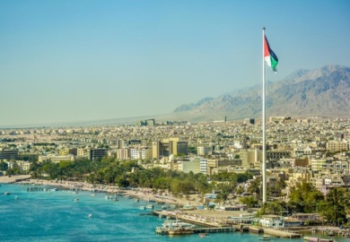
AQABA
With its wealth of other attractions, Jordan’s splendid Red Sea resort is often overlooked by modern-day visitors. But apart from being a delightful place for discerning holidaymakers, this is actually a great base from which to explore various places of interest in southern Jordan.
Aqaba is a fun place. It is a microcosm of all the good things Jordan has to offer, including a fascinating history with some outstanding sites, excellent hotels and activities, superb visitor facilities, good shopping, and welcoming, friendly people, who enjoy nothing more than making sure their visitors have a good time.
But perhaps Aqaba’s greatest asset is the Red Sea itself. Here you can experience some of the best snorkelling and diving in the world. The temperate climate and gentle water currents have created a perfect environment for the growth of corals and a teeming plethora of marine life. Here you can swim with friendly sea turtles and dolphins as they dart amongst the schools of multi-coloured fish. Night dives reveal the nocturnal sea creatures, crabs, lobsters and shrimp, as they search for a midnight snack. Diving with Real Jordan For those who prefer to keep their feet dry, all the deep sea wonders can be viewed through a glass-bottomed boat or by submarine, or you can just relax under the sun on the resort’s sandy beaches. Plus, of course, there are plenty of other water-sport activities available, as well as an extensive and interesting Marine Park.
From as far back as five and a half thousand years ago Aqaba has played an important role in the economy of the region. It was a prime junction for land and sea routes from Asia, Africa and Europe, a role it still plays today. Because of this vital function, there are many historic sites to be explored within the area, including what is believed to be the oldest purpose-built church in the world.
Aqaba International Airport is situated just 20 minutes from the town centre and services regular flights from Amman as well as from several European cities. From the town centre, the borders of Israel, Egypt’s Sinai and Saudi Arabia are no more than a 30-minute drive.
AZRAQ Wetland Reserve
Found near the town of Azraq (approximately 100 km from Amman), the Azraq Wetland Reserve is another preservation project by the Royal Society for Conservation of Nature. Created in 1978, the RSCN established the Azraq Wetland Reserve for the protection and preservation of the land and migratory birds in the area. The impressive wetland exists in the middle of the eastern desert landscape.
History of Azraq Wetland Reserve
In 1992, the natural springs dried up, resulting in an ecological change as the birds who normally migrated to the area stopped returning and moved away. Unfortunately, due to stress on the environment for the country’s water resources, the wetland has been disturbed and has decreased in size. What remains is still a triumph and an important place as the ecological implications of taking resources and water pumping has a profound impact on the wildlife in the region.
Visiting Azraq Wetland Reserve
Visitors to the Azraq Wetland Reserve will be able to enjoy a walk through the various pathways to admire the various birds, including birds of prey. On the reserve, there are also several water buffaloes. There is also the ancient ruins of an old Umayyad aqueduct which is an interesting look into the history of the region. There is also a small museum on the premises which provides information on the thriving past of the Wetland and the sad future of the ever-shrinking ecosystem.
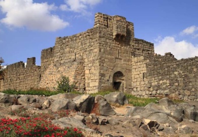
Qasr ARZAQ
On the edge of dusty Azraq, this imposing fort is where TE Lawrence and Sharif Hussein bin Ali based themselves in the winter of 1917–18 during the Arab Revolt against the Turks. Lawrence set up his quarters in the room above the southern entrance, while his loyal followers braved the elements in other areas of the fort. They were holed up here for several months in crowded conditions with little shelter from the intense cold – gaping holes in the roof were patched up with nothing but palm branches and clay.
Despite the hardships endured during his stay at Azraq, TE Lawrence writes fondly about the time spent with his men at arms. In the evenings everyone would assemble before a great fire in the open courtyard and break bread while swapping stories of war, peace and love. At the time, the castle also commanded sweeping views of the nearby palm-fringed oasis at Azraq.
Constructed out of black basalt stone, Qasr Al Azraq was originally three storeys high. Some paving stones in the main entrance have small indentations, carved by former gatekeepers who played a board game using pebbles to pass the time. By the courtyard entrance, look for the carvings of animals and various inscriptions.
Comparatively little is known about the history of Qasr Al Azraq, and there’s been little excavation and renovation. Greek and Latin inscriptions date earlier constructions on the site to around AD 300, coinciding with Roman occupation.
The fort was renovated by the Umayyad caliph Walid II, who used it for hunting and as a military base. Its present form dates to 1237 when it was fortified by the Ayyubids as a defence against the Crusaders. The Turks subsequently stationed a garrison here in the 16th century. In a turn of the tide in 1918, it was from this building that the Arab Revolt launched an attack on Damascus that proved successful in ousting the Turks from the region.
Above the entrance is Lawrence’s Room, strategically overlooking the entry and offset with arrow slits for defence. Opposite the entrance, and just to the left, are the remains of an altar, built in the 3rd century AD by the Romans. In the middle of the courtyard is a small mosque, angled to face Mecca – it dates from the Ayyubid period (early 13th century) but was built on the ruins of a Byzantine church. In the northeast corner of the courtyard, a hole with stairs leads down to a well, full of water until about 20 years ago. In the northwest corner are the ruins of the prison.
The northern sections are residential areas with barely discernible ruins of a kitchen and dining room, and nearby storerooms and stables. The tower in the western wall is the most spectacular, and features a huge door made of a single massive slab of basalt. Lawrence describes in his book Seven Pillars of Wisdom how it ‘went shut with a clang and crash that made tremble the west wall of the castle’.
DANA
Dana is a village near the town of Tafilah, in central-western Jordan. It is situated on the edge of a large natural gorge, Wadi Dana and enjoys spectacular view over Wadi Araba.
Dana is about 500 years old, and preserves many aspects of Jordanian villages of the 19th century villages of Jordan. It hosts Dana nature reserve, one of Jordan’s premier nature reserves with eco-tourism facilities.
The Reserve was established in 1993 in southern Jordan and covers 320 square kilometers.
Originally another community being deserted by its people, Dana village occupies a wonderful site looking out over Wadi Dana and is now gradually coming back to life with the jobs associated with the Reserve. One of the first measures taken by the RSCN was to install a reliable water supply, and the fruit that can now be produced locally is made into jams which are sold at the Reserve shop, together with soap made with the local olive oil. Medicinal herbs, also grown in the valley, are to be found on sale here, as well as silver jewellery made in the workshop nearby. Tourism revenue is reported to be covering all the running costs of the reserve.
Dana embraces two major bio-geographical zones and four distinct vegetation zones and contains a remarkable diversity of landscapes, ranging from wooded highlands and rocky slopes to gravel plains and sand dunes. It supports a wide variety of wildlife, including many rare species of plants and animals.
Dana Nature Reserve is a system of wadis and mountains, which extend from the top of the Rift Valley down to the desert lowlands of Wadi Araba, an elevation drop of over 1600 meters.
The total number of species recorded so far consists of 697 plants, of which 3 are new to science, and 282 animals. Many of these are now very rare and some threatened with extinction animals like the Grey Wolf, Nubian Ibex, the Lesser Kestrel, Eagle Owl and the Desert Monitor Lizard. So far, 45 endangered or vulnerable animals have been found in the reserve, making it truly a place of world importance. Apart from its wildlife, Dana is also rich in archaeology and culture. About 100 archaeological sites have been identified, of which the ancient copper mines in Wadi Feinan are particularly special, being considered the most important archaeological complex in southern Jordan outside of Petra.
Hiking in Dana
Dana offers a selection of trails to key points of interest for both the casual and adventurous hiker. Four of the trails are clearly marked with intermittent piles of stones along the route, and can therefore be hiked independently or with an RSCN guide. The other two trails, which are longer and unmarked, must be hiked with a guide. Guided hikes offer visitors a unique opportunity to enjoy a stimulating walk and learn about the geology, wildlife, and history of Dana in a natural “classroom”.
Easy Trails: NOTE ALL OF THE BELOW ARE WITH QUALIFIED GUIDES WHEN BOOKED THROUGH OUR COMPANY- ages added below of the advise of the official jordanian tourism board
Traditional Tribal Arts Tour : one hour visiting some spectacular viewpoints above Dana Village, exploring the terraced gardens, meeting some local farmers, visiting a traditional bakery, Dana’s Jam Factory and the fruit, soap and silver workshop.
Campsite Trail : two hours circular walk around the campsite area, a favorable place for birding, nesting or migrating.
Wadi Dana Trail : Long hike lovers will enjoy this hiking experience for 14 Km (5-6 hours) of spectacular uphill walk from Dana to Feinan.
Moderate Trails: (up to 47 years old)
Roman Lost Copper Mines Tour (Dana- Feinan- copper mines): 16 Km trail taking 6 hours hiking from Dana to Feinan visiting the copper mines
Griffon Vultures Tour: 2.5 Km moderate trail to Rummana scenic peak for an excellent view of Wadi Araba and an ancient cistern. Here you enjoy 1-2 hours of circular walk. Visitors will pass some magnificent rock structures of sandstone and limestone and Roman and early Islamic archaeology, observeGriffon vultures and other birds of prey, view the beautiful nature of the area covered by Juniper trees, early Islamic ruins.
Village Overland Trail : 8 Km, 3 hour, horizontal moderate trail starts from Rummana Camp past Wadi escarpments, through terraced gardens and Dana Village to Dana Guesthouse and Visitor Centre.
Feinan Copper Mine Tour : Start from Feinan to see ancient copper mines and Tell of Khirbet Feinan with remains of Byzantine churches, a Roman tower, Christian and Islamic graves, and Iron Age remains. It takes 1-2 hours from Feinan.
Waterfalls area Tour : Two and a half hours- 2 Km – moderate trail starting from al-Barra area to the beautiful springs and ancient ruins in Nawatef area going back to al- Barra area.
Hard Trails: (up to 35 years old)
Palm Trees Wadi Tour: This Trail is exactly suitable for adventure lovers since it takes 6-8 hours of hard hike (16 km) up the Wadi past an oasis with a warm spring beginning from al- Barra to Feinan.
Mysterious Nabatean Tomb Tour: 2 km hike, on a hard hike trail to a breathtaking ravine containing Nabatean tombs from al-Barra to Shaq al Reesh then back to al-Barra.
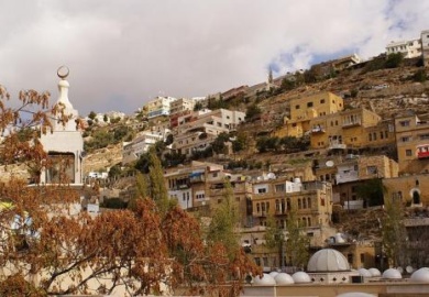
AS SALT
The most historic town in Jordan and a town of picturesque streets and dazzling houses from the late Ottoman period with their characteristic long-arched windows, located 32 km (21 miles) northwest of Amman.
This ancient town was once the capital of Jordan or Balqa region. A 30-minutes drive (approx. 33 km – 21 miles) northwest from Amman transports you back in time to a town of picturesque streets and dazzling houses from the late Ottoman period, with their characteristic long-arched windows.
It’s the ideal place for admiring the architecture, stopping off at the small archaeological museum, and finishing up at As-Salt Zaman, a lovely restored old building in the heart of the town, charmingly furnished with antiques and handicrafts. As-Salt also houses a Handicrafts School where you can admire traditional skills of ceramics, weaving, silk screen printing, and dyeing.
RELIGION
As-Salt has attracted settlers since the Iron Age at least. The area enjoys a moderate climate, a plentiful supply of water and fertile soil. It was also well placed on the north to south trade routes and those running from east to west, linking the interior with Jerusalem, Nablus, Nazareth, and the Mediterranean coast. Its mixed Muslim-Christian population and its trading tradition helped create an atmosphere of tolerance and coexistence.
There are Roman tombs on the outskirts of the town, and during the Byzantine period it was known as Saltos Hieraticon. In the 13th century a fortress was built on the site of the citadel by the Mamluk Sultan Al-Malek Al-Mu’azham, who was based in Cairo. Destroyed by the Mongols in 1260, the fortress was rebuilt a year later by a second Mamluk ruler from Egypt. Six centuries later, in 1840, the forces of yet another Egyptian potentate, Ibrahim Pasha, demolished it again. The Citadel is now the site of a large mosque, which towers over the modern town.
By the early 19th century, As-Salt was a well-off frontier town on the edge of Ottoman Empire and the desert. Useful to all, it was ruled by none. The town was also the center of lucrative trading between the region and urban industries in Palestine.
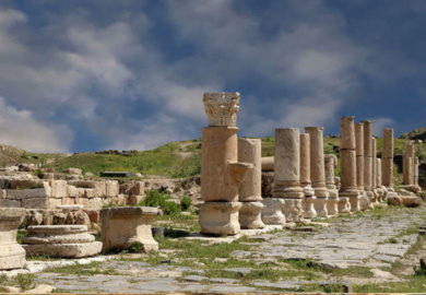
JERASH
A close second to Petra on the list of favourite destinations in Jordan is the ancient city of Jerash, which boasts an unbroken chain of human occupation dating back more than 6,500 years.
Jerash lies on a plain surrounded by hilly wooded areas and fertile basins. Conquered by General Pompey in 63 BC, it came under Roman rule and was one of the ten great Roman cities of the Decapolis League.
The city’s golden age came under Roman rule, during which time it was known as Gerasa, and the site is now generally acknowledged to be one of the best-preserved Roman provincial towns in the world. Hidden for centuries in sand before being excavated and restored over the past 70 years, Jerash reveals a fine example of the grand, formal provincial Roman urbanism that is found throughout the Middle East, comprising paved and colonnaded streets, soaring hilltop temples, handsome theatres, spacious public squares and plazas, baths, fountains and city walls pierced by towers and gates.
Beneath its external Graeco – Roman veneer, Jerash also preserves a subtle blend of east and west. Its architecture, religion and languages reflect a process by which two powerful cultures meshed and coexisted – The Graeco-Roman world of the Mediterranean basin and the traditions of the Arab Orient.
The modern city of Jerash can be found to the east of the ruins. While the old and new share a city wall, careful preservation and planning has seen the city itself develop well away from the ruins so there is no encroachment on the sites of old.
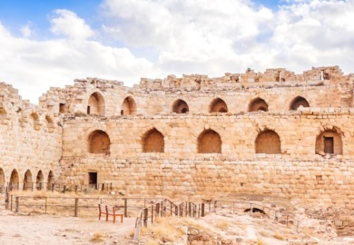
KARAK
The striking silhouette of this fortified town and castle will instantly make you understand why the fates of kings and nations were decided here for millennia.
An ancient Crusader stronghold, Karak sits 900m above sea level and lies inside the walls of the old city. The city today is home to around 170,000 people and continues to boast a number of restored 19th century Ottoman buildings, restaurants, places to stay, and the like. But it is undoubtedly Karak Castle that dominates.
The town is built on a triangular plateau, with the castle at its narrow southern tip. The castle is some 220m long, 125m wide at the north end, and 40m wide at the southern end where a narrow valley deepened by a ditch separates it from the adjoining and much higher hill – once Saladin’s favourite artillery position. Throughout the castle, dark and roughly-shaped Crusader masonry is easy to discern from the finely-crafted blocks of lighter and softer limestone used in later Arab work.
While the castle we see today essentially dates back to the 12th century, Karak has been a fortress since biblical times. The Bible relates how the King of Israel and his allies from Judah and Edom ravaged Moab and besieged its king Mesha in the fortress of Kir Heres, as Karak was then known.
Centuries later, it took the Crusaders some twenty years to erect their vast castle. Once finished in 1161, it became the residence of the lord of Transjordan, by then the most important fief of the Crusader kingdom, rich in produce and tax revenues. After withstanding several sieges in the early 1170s, Karak came under the rule of Reynald of Chatillon, a lord who became known for his recklessness and barbarism. Breaking all treaties, he began looting merchant caravans and Mecca-bound pilgrims, attacked the very homeland of Islam – the Hijaz – and raided Arabian ports on the Red Sea, even threatening Mecca itself. Saladin, the ruler of Syria and Egypt, reacted swiftly. He took the town of Karak by force, burned it down and almost managed to storm the castle as well.
Reynald’s peacetime robbery of a large caravan in 1177 prompted fast retribution from Saladin – who attacked the Crusader kingdom – ending in the defeat of the Crusader army at the Battle of Hattin. Saladin spared most of the captives except Reynald, who he executed himself. The defenders of Karak held out for eight months in a prolonged siege before surrendering to the Muslims who, mercifully, allowed them to walk free.
Once again in Muslim hands, Karak became the capital of a district covering much of Jordan, playing a central role in Middle Eastern politics for the next two centuries. For a time, Karak even became the capital of the whole Mamluk kingdom when Sultan an-Nasir Ahmad grew weary of power struggles in Cairo. Indeed, it took eight separate sieges before his brother and successor as-Salih Ismail took the fortress and returned the royal insignia. It was during these sieges that Karak had the dubious honour of being the first target of modern artillery in the Middle East, as-Salih Ismail making use of cannons and gunpowder.
Under the Ayyubids and early Mameluk sultans, the castle was substantially renovated and the town’s fortifications strengthened with massive towers but seemingly no gates – access to the town was through subterranean passages with entrances still visible today.
In later times, the town more often than not became a refuge for rebels, while the castle was used as the gathering place of tribal councils. Firm Turkish administration was enforced after 1894 and the Mameluk palace inside the castle was used as a prison. The Great Arab Revolt dealt the last blow to Turkish rule, which ended in 1918
A great way to explore Karak Castle is through it’s the sight and sound event. The Castle and its towers are lit by 50 post lights that is accompanied by a showing a documentary film about the history of Karak and the major events that took place since 800 BC.
The film also displays the invasion of Karak by many civilisation including Greek, Nabatean, Byzantine Crusaders and finally by the Ottoman rule in the 19th century.
It also sheds light on the city of Karak with its new development and how Karak is a great example for coexisting between Muslims and Christians.
KINGS WAY
Jordan is a very small country and there are not many roads. If you wish to travel from Amman to Petra, you have 2 options. The fast and direct Desert Highway 15 to Petra or the scenic King’s Highway 35 from Amman to Petra.
The King’s Highway is one of two routes that run from Amman to Petra. The King’s Highway starts in Northern Jordan near the town of Irbid and runs north to south to the town of Wadi Musa (the gateway to Petra). On the map, the King’s Highway is marked with number 35. After Wadi Musa, the King’s Highway continues for a few more kilometers before it merges with Highway 47 to Aqaba.
History of the King’s Highway Jordan
The route of the King’s Highway in Jordan is over 5,000 years old and has been used as a trading route in ancient times. It was used by the Nabataeans to trade and the Roman emperor Trajan dubbed the route the Via Trajana Nova. The Romans not only used the route for trade, but also for military purposes.
With the rise of Christianity in the Byzantine time, many Christian pilgrims followed the route to visit Mt. Nebo where Moses saw the promised land and the baptism site of Jesus in the Jordan River. Until the 16th century, Muslims used the King’s Highways as their main route from Heliopolis (Egypt) through Jordan to Damascus, ending in Resafa (modern-day Syria) where the route merged with another ancient route to Mecca.
Nowadays, the King’s Highway is perfect for people who like driving in Jordan and want to see more of the country and visit many historic sights along the route.
The Desert Highway is perfect for people who have little time and want to go quickly from Amman to Petra. The regional buses from Amman to Petra follow this route as do many tours from Amman.
When you have a little more time (allow all day to be safe) and want to see interesting historic sights you’ll not find in Amman, then the King’s Highway would be your best choice. The King’s Highway from Amman to Petra is 249 km (154 miles) long. This is only slightly longer than the Desert Highway but because of the scenic nature of the route, the winding roads, steep climbs, and descents, it will take you much longer.
MADABA
Just 30km from Amman, along the 5,000-year-old Kings´ Highway, is one of the most memorable places in the Holy Land. After passing through a string of ancient sites, the first city you reach is Madaba, known as the “City of Mosaics.”
Best known for its spectacular Byzantine and Umayyad mosaics, Madaba is home to the famous 6th century Mosaic Map of Jerusalem and the Holy Land. With two million pieces of vividly coloured local stone, it depicts hills and valleys, villages and towns as far as the Nile Delta.
The Madaba Mosaic Map covers the floor of the Greek Orthodox Church of St. George, which is located northwest of the city centre. The church was built in 1896 AD, over the remains of a much earlier 6th century Byzantine church. The mosaic panel enclosing the Map was originally around 15.6 X 6m, 94 sq.m., only about a quarter of which is preserved.
Other mosaic masterpieces found in the Church of the Virgin and the Apostles and in the Archaeological Museum depict a rampant profusion of flowers and plants, birds and fish, animals and exotic beasts, as well as scenes from mythology and the everyday pursuits of hunting, fishing and farming. Literally, hundreds of other mosaics from the 5th through the 7th centuries are scattered throughout Madaba’s churches and homes.
In line with Jordan’s commitment to restoring and preserving its mosaic masterpieces, Madaba’s extensive Archaeological Park and Museum complex encompasses the remains of several Byzantine churches, including the outstanding mosaics of the Church of the Virgin and the Hyppolytus Hall, part of a 6th century mansion.
Close to the Church of the Virgin is the Madaba Institute for Mosaic Art and Restoration, which operates under the patronage of the Ministry of Tourism. The only project of its kind in the Middle East, the Institute trains artisans in the art of making, repairing and restoring mosaics.
MOUNT NEBO
Drive along the same route prophet Moses (pbuh) was forbidden to travel on by the King of Edom (Numbers 20), and picture yourself standing where Moses was laid to rest, and where the late Pope John Paul II tread on his first pilgrimage of the millennium.
Visit the Sanctuary at Nebo: the memorial of Moses (pbuh), the presumed site of his death and burial place, and a center for pilgrimages since earliest Christian times. You’ll be inspired by the biblical feel from start to finish as you experience this divine tour.
Mount Nebo is one of the most revered holy sites of Jordan, located 10 km (6 miles) west of the Roman Byzantine town of Madaba, for this is where Moses (pbuh) was buried. The site’s association with the last days of Moses is described in moving words in Deuteromony (34:1-7). The episode of Balak and Balam (2:13-26) also took place here.
The site’s other name is Pisgah: “And Moses went up from the plains of Moab to Mount Nebo, to the top of Pisgah which is opposite Jericho”. From the mountaintop, which is the highest point in the Moabite range, rising to about 800 meters at its apex, you can admire the dazzling view across the Jordan Valley and the Dead Sea, to the rooftops of Jerusalem and Bethlehem.
Centuries ago, pilgrims flocked to Mount Nebo on their final destination to visit the sanctuary. These pilgrims left behind vivid accounts of their travels, which helped archaeologists identify this sanctuary.
In the summer of 1933, excavations at Syagha, one of the highest peaks at Nebo, began under the direction of the Jerusalemite Franciscan Fathers. Three long archaeological campaigns had previously resulted in the discovery of the Basilica and of a large monastery, which had continued to expand through the 6th century.
Mount Nebo’s first church was constructed in the 2nd half of the 4th century to commemorate the place of Moses’ death. It had three apses and was preceded by a vestibule paved with plain white mosaic; two funeral chapels stood to the north and south of the lateral apses.
Six tombs have been found hollowed from the natural rock beneath the mosaic-covered floor of the church. In the present presbytery you can see remnants of mosaic floors from different periods. The earliest of these is a panel with a braided cross presently placed on the east end of the south wall.
The Old Diaconicon Baptistery
The three apsed cella (cella trichola) was preceded by a courtyard. In August 531 AD a Diaconicon Baptistery was built to the north of the courtyard against one of the funeral chapels. It was reached by a short flight of stairs, as it was one meter lower than the floor of the courtyard.
This rectangular room contained the baptismal stone fountain fashioned in the form of a cross and coated with a thick layer of time plaster. Two Greek inscriptions show the date of the mosaic floor (August 531), the name of the mosaicists, Soel, Kaium, and Elias, and the name of the Bishop of Madaba, Elias.
In its decorative scheme, the mosaic floor is divided into three distinct panels in floor registers depicting pastoral and hunting scenes.
The 5th-7th Century Basilica
In the latter half of the 6th century the monks decided to enlarge their sanctuary. When removing the facade, the primitive church became the presbytery and the three naves were constructed on the site of the old vestibule and courtyard.
The mosaic work decorating the new basilica was integrated into a single large design or composition centered on a grapevine, with a swastika motif running along the perimeter of the interior of the building. Of this large composition, all that remains today are some geometric designs from the two lateral naves, a large section of the panels that adorned the intervals between the columns, and two fragments from the central nave.
The New Diaconicon
After the funeral chapel and the Diaconicon Baptistery were dismantled, the floor was adjusted to level with the rest of the basilica, making a single large chapel divided by stairs and railing into two separate rooms. The eastern room was decorated with mosaic depicting animals and flowers inserted in a geometrical frame; the western room was graced with geometrical motifs.
The elongated chapel might have been used as the Diaconicon of the basilica and as a chapter room for the monks.
Perhaps during the same period in which the Diaconicon was altered and embellished, the ancient funeral chapel was destroyed, and a new room, replete with mosaics, was built instead. This was replaced by a new baptistery with its own mosaics in 597-598 AD. Over the threshold at the entrance of the baptistery, was a welcoming inscription, “Peace to All”, placed to greet visitors entering the chapel.
The Theotokos Chapel
During the first decade of the 7th century, the western door to the baptistery was walled up, three rooms of the monastery were destroyed, and the floor was leveled with the rest of the basilica. This provided the basis and foundation for the construction of the Theotokos (Mother of God) chapel.
This chapel had its own apse and was divided by a railing into two distinct rooms. The floor decoration received special attention with rich geometric multi-color designs encompassing pictures of flowers, animals as well as a ciborium above an altar flanked by two bulls and gazelles.
While the sanctuary was undergoing various stages of architectural development, a parallel series of improvements and changes were taking place in the adjacent monastery. From its primitive nucleus of cells discovered by the archaeologists just outside the basilica on the northern side of the mountain, the complex gradually expanded into a monastic community of a respectable size in that very monastic Byzantine world.
The restoration work preserved for future generations this extraordinary Monument of the Faith and brought new life to a sanctuary constructed in ancient times to honor Moses, the Prophet and man of God. Since September 4, 1976, the annual feast of Moses is celebrated and the Christian community join with the Franciscan Fathers in this solemnity.
The Italian artist, Giovanni Fantoni, is credited with designing the metal decorations inside the sanctuary as well as the Serpentine Cross (The Brazen Serpent Monument) on the exterior. These are symbolic of the bronze serpent taken by Moses (pbuh) into the desert, and the cross upon which Jesus (pbuh) was crucified.
About 1 km east of Mount Nebo, you can see the spring of Moses, mentioned by Egeria, Peter the Iberian, and Theodosius. In the springtime, this area is dotted by Eucalyptus trees, which grow close to two churches built in the 6th century, with enchanting mosaics: the churches of Deacon Thomas and Kayanos which were adorned with another mosaic pavement in the 7th Century. The churches were destroyed by a powerful earthquake which hit the region in AD 749.
PELLA
The first literary reference to the city is from the 19th century BC when it is mentioned in Egyptian texts as Pihilum, or Pehel. It was a flourishing trade center, with links with Syria and Cyprus as well as Egypt. On the division of Alexander’s Empire, its name was changed to Pella – either in honour of Alexander’s birthplace, or as a Hellenisation of Pihilum, or both. It changed hands between the Ptolemies and Seleucids,
After Pompey’s conquest in 63 BC its prosperity increased further as one of the cities of the Roman Decapolis, and the Roman city more or less eliminated the Hellenistic city. The Byzantine era saw a revitalization of Pella, as trade routes strengthened and local industries developed. Under them there was yet more building, in particular of churches – on a hillside overlooking the valley stands one such church, while another is near the river at the foot of the ancient tell.
After the 7th century Arab conquest, Pella continued as an Umayyad city for just over 100 years, and some superb pottery remains have been found here, made in the Jerash kilns. But like so many places in Jordan, the city was destroyed by the terrible earthquake of 747 AD. The site continued to be occupied during the Abbasid and Mamluk periods, but it was now a much smaller and more rural community. There was still a mud-brick village on the tell until 1970, but it was bombed in an Israeli strike across the border.
Qasr Amra
A bathhouse from the second Islamic Caliphate decorated with frescoes of constellations, pleasure gardens, and naked ladies.
Standing in the Jordanian desert some 50 miles east of Amman, Qasr Amra is one of several qusur or “desert castles” built under the Umayyad Caliphate and probably the best known extant example of these buildings characteristic of the Damascus-based dynasty.
Most likely constructed somewhere between 723 and 743 by Walid Ibn Yazid (the future caliph Walid II), Qasr Amra was a small royal retreat consisting of an audience hall and baths. In addition to simply being a well-preserved Umayyad structure, Qasr Amra is particularly notable for the frescoes that adorn the interior walls and ceilings.
The frescoes are significant because they provide a rare glimpse at a largely secular and transitional style of early Islamic art. Because the frescoes were painted near the beginning (relatively speaking) of the Islamic era, and under the Umayyads – whose power base was in Syria, rather than the Arabian peninsula – the frescoes are perhaps surprisingly figurative and display clear Byzantine and Persian influences, representing what one antiquarian described as “an artistic renaissance of Hellenistic art.”
The subject matter varies by room. Scenes in the audience hall depict activities as hunting, eating fruit, drinking wine, and peeking at nude women. One panel in this room also shows six kings – the Byzantine Emperor, the Persian Shah, the Visigoth king of Spain, the Negus of Ethiopia, and two more who are most likely Turkic and Indian or Chinese rulers — all paying homage to the Caliph, with inscriptions in Arabic and Greek.
Within the baths, the apodyterium (changing room) features animals doing human things, like playing music; the tepidarium (warm bath) is decorated with natural scenes and plants and trees, and more nude women; and the caldarium (hot bath) boasts a domed ceiling bearing the zodiac and various other constellations. The stellar imagery in the caldarium is particularly significant, as it is the earliest known example of the night sky being depicted on a non-flat surface.
Though seemingly incongruous given the more abstract and geometric styles in later Islamic art, the frescoes of Qasr Amra were apparently in accordance with the medical opinions of contemporary Arab doctors, who believed bathing drained the bather of the three “vital principals” (the animal, the spiritual, and the natural) and that baths should be decorated to refresh these principals.
The site also bears evidence of an accompanying defensive castle that no longer stands, as well as a sophisticated animal-powered hydraulic system that provided water to the baths and most likely irrigated a garden. Today, Qasr Amra is a UNESCO World Heritage Site.
Shobak
Shobak is one of Jordan’s most significant and impressive historical sites located on the road to Petra about 190 km (118 miles) south of Amman where stands an impressive castle as a lonely reminder of former Crusader glory.
Just off the King’s Highway 190 km (118 miles) south of Amman and less than an hour north of Petra stands an impressive castle as a lonely reminder of former Crusader glory dating from the same turbulent period as Al-Karak, crowning a cone of rock, which rises above a wild and rugged landscape dotted with a grand sweep of fruit trees below.
It is today known as Shobak, but to the Crusaders it was Mont Real (Crak de Montreal) or Mons Regalis, the Fortress of the Royal Mount. It was built in 1115 by King Baldwin I of Jerusalem to guard the road from Damascus to Egypt, and was the first of a string of similar strongholds in the Latin Kingdom of Jerusalem.
Salahuddin Al-Ayyoubi (Saladin) attacked it on several occasions, finally capturing it in 1189 (only 75 years after it was raised) when the Crusaders were losing their foothold throughout the Holy Land. Inscriptions by Saladin’s proud successors appear on the castle wall. In 1260, it passed to the Mamluks whom restored it in the following century, adorning its walls and towers with Arabic inscriptions which testify to their work. Since then it has lain largely untouched, gradually falling into greater disrepair.
The castle’s exterior is impressive, with a forbidding gate and encircling walls three layers thick. The walls and projecting towers are still reasonably intact, but inside the castle consists mainly of tumbled stones with a few walls and arches. One of the most fascinating remains is the ancient well-shaft cut deep into the rock, with 375 steps leading down to the water supply at the bottom.
There are several small villages in the area, for there are abundant springs and fertile valleys where olives, grapes, figs, and apricots are grown, as well as grain crops. Earlier this century the castle itself was occupied by a few local families, and there was a market within its walls which served all the villages. Before 1948 trade links were mainly with Palestine, and the villagers would make regular trips to Beersheba to sell livestock and ghee (camel butter), and to Hebron and Jerusalem to buy sugar, oranges and cloth. Today they have to go to Ma’an.
UMM AR RASSAS
Located 75 km (46 miles) south of Amman, an ancient city mentioned in The Old and New Testaments housing some of the finest Byzantine church mosaics in the Middle East and the Church of St. Stephen with its perfectly preserved mosaic floor which is the largest in Jordan.
The Old and New Testaments mention it, the Romans fortified it, and the local Christians were still embellishing it with Byzantine-style mosaics well over 100 years after the beginning of Muslim Umayyad rule: Kastron Mefaa, modern Umm Ar-Rasas, a UNESCO World Heritage Site, indeed, has a long history to tell.
This rectangular walled city, located about 30 km (18.6 miles) southeast of Madaba, lays in ruins, but several buildings in its eastern part, including churches, a courtyard with a well, staircases and beautifully curved stone arches have been excavated and restored. Recent excavations here have uncovered some of the finest Byzantine church mosaics in the Middle East.
The main attraction, though, lies outside the city walls: it is the newly unearthed Church of St. Stephen with its perfectly preserved remarkable mosaic floor, the largest one in Jordan. It contains the images and portraits of 27 Old and New Testament cities of the Holy Land from both east and west of the Jordan River and of Egypt, making it a discovery second only to the Mosaic Map of Madaba.
Less than 2 km north of the fortified town, the highest standing ancient tower of Jordan puzzles the specialists: a 15 meter high, Byzantine square tower with no door or inner staircase, thought to be used by early Christian monks seeking solitude, now inhabited by swarms of birds.
Umm Qais,
situated 110 km (68 miles) north of Amman on a broad promontory 378 meters above sea level with a magnificent view over the Yarmouk River, the Golan Heights, and Lake Tiberias, this town was known as Gadara, one of the most brilliant ancient Greco-Roman cities of the Decapolis; and according to the Bible, the spot where Jesus (pbuh) cast out the Devil from two demoniacs (mad men) into a herd of pigs (Mathew 8:28-34).
In ancient times, Gadara was strategically situated, laced by a number of key trading routes connecting Syria and Palestine. It was blessed with fertile soil and abundant rainwater. This town also flourished intellectually in the reign of Augustus and became distinguished for its cosmopolitan atmosphere, university’s scholars, attracting writers, artists, philosophers and poets, the likes of satirist Menippos (2nd half of the 3rd century BC), the epigrammist Meleagros, and the rhetorician Theodoros (14-37 AD). Gadara was also the resort of choice for Romans vacationing in the nearby Himmet Gader Springs.
Archaeological surveys indicate that Gadara was occupied as early as the 7th century BC. The Greek historian, Polybius, described the region as being under Ptolemaic control at the time. The Seleucid ruler Antiochus III conquered it in 218 BC, naming the city Antiochia and Seleucia. In 63 BC, Pompey liberated Gadara and joined it to the Roman league of ten cities, the Decapolis.
Soon after, the fortunes of Gadara improved rapidly and building was undertaken on a large scale, carried out for the love of Pompey’s freed man Demetrius, who had been born there.
During these early years of Roman rule, the Nabataeans (with their capital in Petra), controlled the trade routes as far north as Damascus. Unhappy with the competition, Mark Anthony dispatched King Herod the Great to weaken the Nabataeans, who finally gave up their northern interest in 31 BC. In appreciation for his efforts, Rome rewarded Herod with Gadara.
The city reached its peak of prosperity in the 2nd century AD. New colonnaded streets, temples, theaters, and public baths sprouted. Meleagros compared Gadara with Athens, which testifies to the city’s status as a creative center of Hellenism in ancient Near East.
Christianity spread slowly among the inhabitants of Gadara. Starting from the 4th century, its bishop attended the ecclesiastical councils of Nicaea, Chaleedon and Ephesos. Despite his attendance, the city was no longer a seat of learning. During the 6th century, decline set in, and in 636 AD a decisive military clash between Byzantines and Arab Muslims took place not far from Gadara. There is no evidence, however, of widespread destruction in the city.
Umm Qais’s charm still lingers today. A large portion of the western Roman Theater has survived history’s upheavals. Vaulted passageway supports its rows of seats, built of hard basalt stones. A row of elaborately carved seats for dignitaries stand near the orchestra, and in the center was a large headless white marble statue of Tyche, goddess of fortune and of the city, now displayed at the local museum.
Across from the theater is the main colonnaded street (cardo), which was in all likelihood the town’s commercial center. Also, near the black basalt theater is the Terrace, which hosts a courtyard, a church and a basilica. Further west of the Terrace and along the east-west colonnaded street (decumanus), ruins of the Nymphaeum, a bath complex and a well-preserved Roman Mausoleum can be seen. After a few hundred meters one can barely make out remains of what was once a Hippodrome.
WADI MAJIB
Geography
During the last ice age the water level of the Dead Sea reached 180 metres (590 ft) below sea level, about 240 metres (790 ft) higher than it is today. It flooded the lower areas of the canyons along its banks, which became bays and begun to accumulate sediments. As the climatic conditions changed, about 20,000 years ago, the water level of the lake dropped, leaving the re-emergent canyons blocked with lake marl. Most canyons managed to cut through their plugged outlets and to resume their lower courses. However, Wadi Mujib, abandoned its former outlet by breaking through a cleft in the sandstone. This narrow cleft became the bottleneck of an enormous drainage basin with a huge discharge. During the years the cleft was scoured deeper and the gorge of Wadi Mujib was formed.
The Mujib Reserve of Wadi Mujib is located in the mountainous landscape to the east of the Dead Sea, in the southern part of Jordan Valley Jordan , approximately 90 kilometres (56 mi) south of Amman. A 212-square-kilometre (82 sq mi) reserve was created in 1987 by the Royal Society for the conservation of nature and is regionally and internationally important, particularly for the bird life that the reserve supports. In 2011, UNESCO declared Mujib biosphere reserve Mujib It extends to the Kerak and madaba mountains to the north and south, reaching 900 metres (3,000 ft) above sea level in some places. This 1,300-metre (4,300 ft) variation in elevation, combined with the valley’s year round water flow from seven tributaries, means that Wadi Mujib enjoys a magnificent biodiversity that is still being explored and documented today.The reserve consists of mountainous, rocky, and sparsely vegetated desert (up to 800 metres (2,600 ft)), with cliffs and gorges cutting through plateaus. Perennial, spring-fed streams flow to the shores of the Dead Sea.
Over 300 species of plants, 10 species of carnivores and numerous species of permanent and migratory birds have been recorded until this date. Some of the remote mountain and valley areas are difficult to reach, and thus offer safe havens for rare species of cats, goats and other mountain animals.
The slopes of the mountainous land are very sparsely vegetated, with a steppe-type vegetation on plateaus. Groundwater seepage does occur in places along the Dead Sea shore, for example at the hot springs of Zara, which support a luxuriant thicket of Acacia, Tamarix,Phoenix and Nerium, and a small marsh. The less severe slopes of the reserve are used by pastoralists for the grazing of sheep and goats.
The hot springs of Hammamat Ma’in lie close to the borders of the reserve are heavily used for tourism and recreation.
The Jordanian military have a temporary camp in the south of the reserve.
The Mujib Dam was completed in 2004 at the bottom of the wadi, where the modern road crosses the river. As a result, a large lake has formed. Today, Wadi Mujib is fed by seven tributaries.
Biblical history
Wadi Mujib, the biblical Arnon stream, has always been an important boundary-line. For a time it separated the Moabites from the Amorites.
After the Hebrew settlement it divided, theoretically at least, Moab from the tribes of Reuben and Gad. But Moab, in fact, lay as much to the north as it did to the south of the Arnon. To the north, for example, were Aroer, Dibon, Medeba, and other Moabite towns. Even under Omri and Ahab, who held part of the Moabite territory, Israel did not hold sway farther south than Ataroth, about ten miles north of the Arnon.
Mesha in his inscription (Mesha Stele, line 10) says that the Gadites (not the Reubenites) formerly occupied Ataroth, whence he in turn expelled the people of Israel. He mentions (line 26) his having constructed a road along the Arnon. The ancient importance of the river and of the towns in its vicinity is attested by the numerous ruins of bridges, forts, and buildings found upon or near it. Its fords are alluded to by the Book of Isaiah. Its “heights,” crowned with the castles of chiefs, were also celebrated in verse.
Animals
As well as resident birds, the reserve is strategically important as a safe stop-over for the huge number of migratory birds which fly annually along the Great Rift Valley between Africa and northeast Europe. It is possible to see the following birds in Mujib:
Many carnivores also inhabit the various vegetation zones in Mujib, such as the striped hyena and the Syrian wolf. One of the most important animals in Mujib is the Nubian ibex, a large mountain goat which became threatened as a result of over-hunting.
Walk in water through a deep sandstone gorge of Wadi Mujib.
Experience Jordan’s most famous river canyon!
The terrain of the Wadi Mujib Reserve consists of rugged, arid mountains and flowing rivers. The deeply cut sandstone mountains of the Mujib Reserve span an elevation drop of over 1,200 meters: from 900m above sea level to 400m below – the lowest ground level on Earth. Because of this dramatic change in altitude and the presence of several flowing rivers.
Mujib is a very rough, warm area and the walk is called adventure walk because it contains swimming and hiking for long hours in addition to descending a 20 m high waterfall. They are difficult yet fun trails and one has to have the ability to swim and have no fear of water and heights. It is tough, exciting, offering a chance to swim and bathe in the cool, clear waters of the Mujib and Malaqi rivers. Participants should expect to climb rocks against water flows and jump into pools of water.
The most exciting attraction of Mujib is the adventure tour along the river: an all day trip which takes you through deep canyons and pools where you can swim and enjoy the spectacular scenery and wildlife.
Mujib is a wonderful place for nature lovers who are fit and enjoy walking. Facilities are simple and it can get very hot in summer.
The Ibex Trail : (2-3 hours) begins at the Mujib Bridge Reception by the Mujib Bridge on the Dead Sea highway, from where a guide will escort you south for a short distance along the highway before turning onto a steeply ascending trail into the nature reserve. After the first steep climb it diverges to the south, following a wide track running parallel to the Dead Sea. The Sea provides a startlingly blue backdrop throughout the hike. About one third of the distance along the trail, there is an optional detour up the mountainside to Qasr Riyash, a ruined fortification of uncertain date. Villagers say that it is one of four castles in the area, occupied by a powerful Bedouin sheikh known as Riyash. Each of his sons reputedly occupied a castle, until a fight erupted over grazing rights and all of them were killed. The climb to the castle is arduous but offers breathtaking views over the Dead Sea.
Returning to main track, the hike continues towards the Raddas Ranger Station, dipping up and down across a number of dry wadis. There are an amazing variety of rock colours and formations along the route and as you near the ranger station, the famous rock “statue” of Lots wife can be seen on the seaward edge of the reserve. It is said that while fleeing the villages of Sodom and Gomorrah, Lot’s wife ignored the warning not to look back and was turned into a pillar of salt. It takes 3 hours to get to the rangers station (4 km) At the station, there is a large fenced enclosure in which you can see a small breeding herd of magnificent Nubian Ibex– a wild ‘mountain goat’ with long, impressively curved horns. This animal was once common in the region but has been decimated by hunting. Mujib is one of the few safe havens for Ibex, in the reserve, there is a captive breeding programme to boost the wild population. In recent years, many Ibex from this enclosure have been released into the reserve to replenish the wild population that was devastated by hunting. After a rest at the station, visitors hike from the station to the entrance of the reserve through a road that takes 1.5 hours.
Mujib Biosphere Reserve
This wonderful reserve, which ranges from an altitude of 900m above sea level to 400m below, was originally established by the RSCN for the captive breeding of the Nubian ibex, but it also supports a surprising variety of over 400 species of plants (including rare orchids), 186 species of birds and 250 animal species, including the Syrian wolf, striped hyena, caracal and Blandford’s fox. It’s also an important staging post for migratory birds travelling between Africa and Europe. The reserve faces several challenges but it’s encouraging to see parties of schoolchildren here, as the future of Jordan’s ecological heritage is in their hands. The visitor centre is along the Dead Sea Highway, about 20km south of the Dead Sea resorts, beside a suspension bridge across Wadi Mujib. Guides are compulsory for all but the Siq Trail and should be booked in advance through the RSCN. Only 25 people per day are allowed on each trail and there’s a minimum group size of three on some trails. Apart from the Ibex Trail, children under 16 are not allowed. Life jackets are provided. There are three wet trails (open between 1 April and 31 October) and two dry (open year-round). The best time to visit is April and May, although February and March, and October and November are the high seasons. The region is extremely hot and dry for most of the year, so guided treks usually begin early in the morning. For the wet trails, you may be wading up to your chest in water (or swimming) so bring a swimming costume, towel, walking shoes that can get wet, and a waterproof bag for your valuables and camera. A spare set of clothes is also recommended.